Hello everyone.
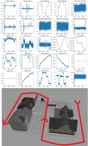
I made a short outdoors flight of 10 minutes with hector quadrotor on Ubuntu 16.04 Gazebo 7. The sensor readings and the path images are as attached. The flight was simple. I took of slowly, moved forward turned, moved forward again, turned, moved forward and landed. Only a few times I got higher or lower.
The altitude graps are taken from gps, sonar height and altimeter sensors and they show different values. Especially, field.altitude_x(gps height), range(sonar height value), field.altitude_y(altimeter height) and pressre height values are different. Some show me climbing up up and up all the time while I flew at a constant height almost all the time except short take offs and lands. The field acceleration values are very much noisy also.
Do you think this sensor grapics are consistent with the flight? Can ros create false sensor readings?
